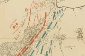
This “illustrative map of battle-grounds of August 28th, 29th, & 30th in the vicinity of Groveton, Prince William Co., VA” – the Second Battle of Bull Run– came from a survey made under the authority of U.S. Secretary of War George W. McCrary. It shows “the relative positions of the Confederate and United States armies in the battle of the 29th of August 1862, at 2 P.M. as given in the evidence of witnesses in the trial, in 1862, before the Army Board, in the official reports, and laid down on the map by the counsel.”
The map shows topography, vegetation, rivers, roads, troop positions, towns, and residents. It comes from the same series of maps as those collected or created by the Confederate States of America that were acquired by the U.S. War Department by capture or surrender during the Civil War, or by donation or purchase after the War.


