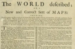
Herman Moll began work on “The World Described or, A New and Correct Sett of Maps” in 1707 and continued to work until it was completed in 1717. Originally published as a folio edition, this series took into account all of the known parts of the globe.
On this page, Moll describes the atlas as:
A New and Correct Sett of MAPS: shewing, The Kingdoms and States in all the Known Parts of the Earth, with principal Cities, and most considerable Towns in the World. Wherein the Errors of the ancient Geographers are corrected according to the latest Observations of Travellers, as communicated to the Royal Society of London, and the Royal Academy of Paris. Each Map is neatly engraved on Copper by HERMAN MOLL, Geographer, and printed on two Sheets of Elephant-Paper, so that the Scale is large enough to shew the Chief Cities and Towns, as well as Provinces, without appearing in the least confus’d. And to render these Maps more acceptable, there is engraved on several of them what is most remarkable in those Countries.


")
")