This map shows the Alaskan territorial island of Attu—an Aleutian Island closer to Japan than to mainland Alaska. Japanese forces occupied Attu on June 7, 1942, during World War II. This set the stage for the only WWII land battle that would take place on U.S. soil.
When the Japanese invaded, there were less than 50 people on Attu island. Japanese forces took the Aleut/Unangax̂ people from Attu hostage, sending them to Japan as prisoners of war. By 1943, the population on Attu had swelled to over 2,300 Japanese soldiers settling in to defend the island. On May 11, 1943, the Battle of Attu began.
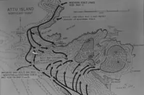
The map shows the landings of the northern and southern forces of US troops, as well as the routes by which these two forces joined together to sweep the Japanese forces toward the sea.
The island was the scene of some of the bloodiest fighting in the Pacific campaign. American forces landed uncontested while the Japanese dug in at higher ground. When the Japanese attacked, 549 American troops were killed, as well as 2,351 Japanese. On May 29, the battle ended with one of the largest banzai charges in the Pacific campaign by the remaining Japanese forces, many detonating grenades against their chests instead of facing surrender. Only 28 Japanese survived.


