Herman Moll began work on “The World Described or, A New and Correct Sett of Maps” in 1707 and continued to work until it was completed in 1717. Originally published as a folio edition, this series took into account all of the known parts of the globe.
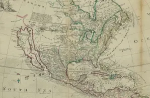
This map, Plate VII, is described in the Atlas’s Index as:
NORTH-AMERICA, with the Harbours of Boston, St. John, Port Royal, Cathagena, &c. and Capt. James’s and Captain Hudson’s Tract of Sailing from Great Birtain to this Part of the World, in search of new Discoveries; also a View of the Stage, and the manner of fishing for, curing, and drying Cod at Newfoundland.


