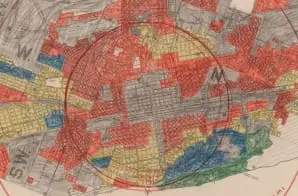
This is a redlining map for Birmingham, Alabama. These maps were created and annotated to show mortgage lending risk by neighborhood type, including residential, commercial and industrial areas. Residential districts are marked by different colors related to the level of risk in lending in those neighborhoods. These types of maps were later known as redlining maps related to the color given to the neighborhoods that were measured as most risky for loans.
Neighborhoods were evaluated by assessors based on several factors, including quality of the housing, sales and rental rates, land quality, and population of the neighborhood. Neighborhoods that included minority (especially African-American) and immigrant communities were often graded as “Fourth Grade” or “Hazardous,” the riskiest category for loans.


