• Login
  • Register
  • FAQ
  • Contact Us
  • Home
  • Documents
  • Activities
  • Activity Tools
    • All Tools
    • Analyzing Documents
    • Discussion Topic
    • Compare and Contrast
    • Zoom/Crop
    • White Out / Black Out
    • Spotlight
    • Finding a Sequence
    • Making Connections
    • Mapping History
    • Seeing the Big Picture
    • Weighing the Evidence
    • Interpreting Data
  • Popular Topics
    • See All
    • National History Day
    • The Constitution
    • Sports: All-American
    • Rights in America
    • American Indians
    • Women's Rights
    • American Revolution
    • The Civil War
    • World War I
    • World War II
    • The Vietnam War
    • 1970s America
    • Congress
    • Amending America
    • Elections
    • What Americans Eat
    • Signatures
    • Nixon and Ford Years
  • Resources
    • Getting Started
    • Document Analysis
    • Activity-Creation Guide
    • Manage Assignments
    • iPad App
    • Presentation Materials
    • Webinars
      • Recorded Webinars
      • Live Webinars
MENU
DocsTeachThe online tool for teaching with documents, from the National Archives National Archives Foundation National Archives

Dale Creek Bridge, West of Cheyenne, Wyoming

1869

Print
Add to Favorites:
Add
Saving document...
Your document has been saved.
Add all page(s) of this document to activity:
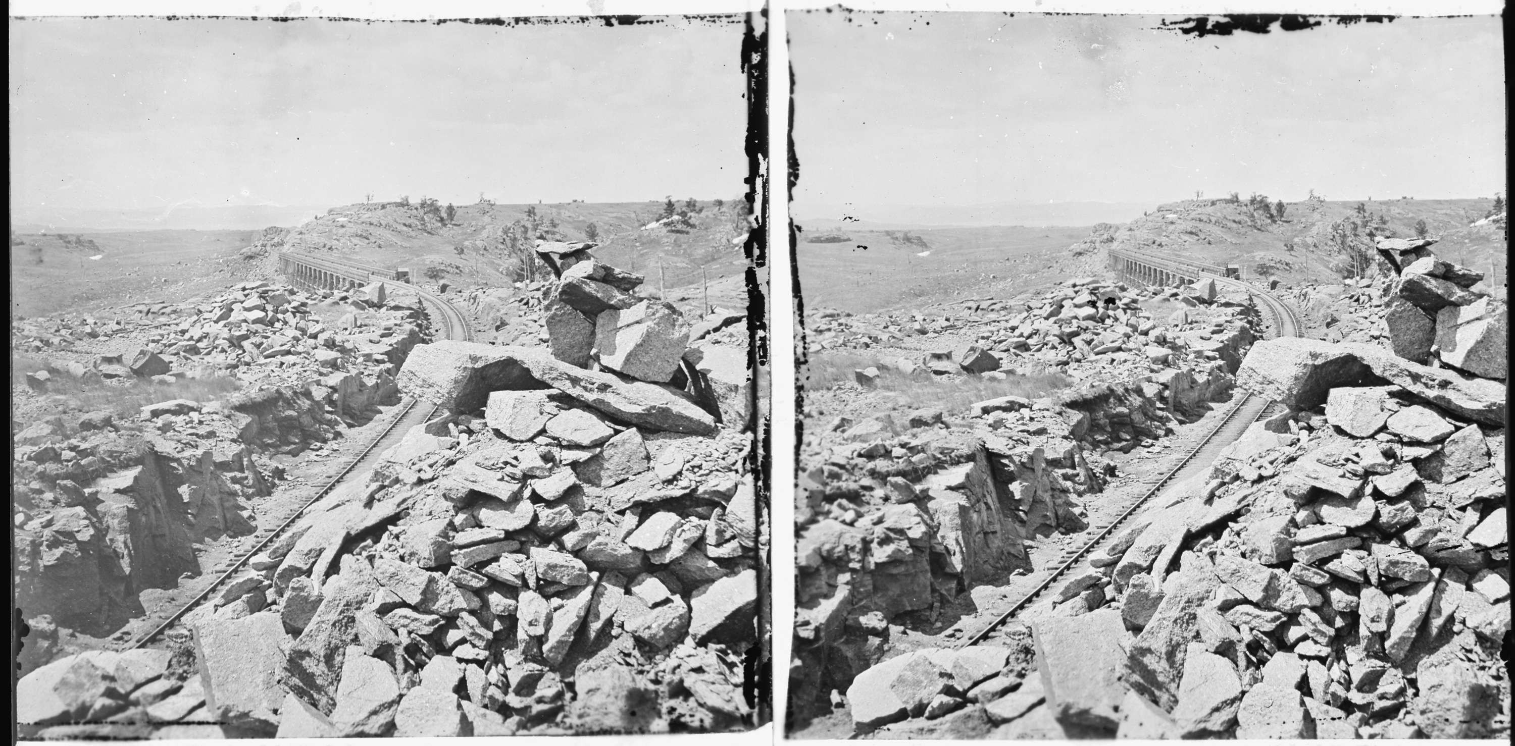
In the second half of the 19th century, the U.S. Government sponsored four major expeditions to explore and map the regions west of the Mississippi River. One of these, known as the Hayden Survey because it was led by Ferdinand Vandeveer Hayden, first explored the area around Yellowstone in Wyoming and later Colorado. This survey was also known as the "U.S. Geological and Geographical Survey of the Territories" and lasted from 1867 to 1879.

Photographer William Henry Jackson and artists Thomas Moran and Henry Wood Elliot accompanied the survey to document the scenes for those back east. Jackson took this photograph near Cheyenne, Wyoming. The Hayden Survey's illustrated report on its 1871 studies in Yellowstone influenced Congress to establish that area as the first national park.
This primary source comes from the Records of the U.S. Geological Survey.
National Archives Identifier: 517377
Full Citation: Photograph 57-HS-841; Dale Creek Bridge, West of Cheyenne, Wyoming; 1869; Hayden Survey, William H. Jackson, Photographs, 1869 - 1878; Records of the U.S. Geological Survey, Record Group 57; National Archives at College Park, College Park, MD. [Online Version, https://www.docsteach.org/documents/document/dale-creek-bridge, January 28, 2023]
Return to ResultsReturn

Rights: Public Domain, Free of Known Copyright Restrictions. Learn more on our privacy and legal page.

  • Explore Primary Source Documents
  •  
  • Discover Activities You Can Teach With
  •  
  • Create Fun & Engaging Activities
Follow us on Twitter:twitter
Follow us on Facebook:facebook
Please enter a valid email address

View our webinars:youtube

Get our iPad app:apple
New Documentsshare
New Activitiesshare

The National Archives

DocsTeach is a product of the National Archives education division. Our mission is to engage, educate, and inspire all learners to discover and explore the records of the American people preserved by the National Archives.

The National Archives and Records Administration is the nation's record keeper. We save documents and other materials created in the course of business conducted by the U.S. Federal government that are judged to have continuing value. We hold in trust for the public the Declaration of Independence, the Constitution, and the Bill of Rights — but also the records of ordinary citizens — at our locations around the country.
  • All Education Programs
  • Student Visits
  • Distance Learning
  • Professional Development
  • National Archives Museum
  • Presidential Libraries
  • Archives.gov
  • National Archives Foundation


Creative Commons License

Except where otherwise noted, DocsTeach is licensed under a Creative Commons Attribution-NonCommercial-ShareAlike 4.0 International License. Primary source documents included on this site generally come from the holdings of the National Archives and are in the public domain, except as noted. Teaching activities on this site have received the CC0 Public Domain Dedication; authors have waived all copyright and related rights to the extent possible under the law. See our legal and privacy page for full terms and conditions.